NWS Los Angeles(@NWSLosAngeles) 's Twitter Profileg
NWS Los Angeles

@NWSLosAngeles

Official Twitter account for the National Weather Service Los Angeles. Details: https://t.co/XR2JbmS8pl

ID:599632006

linkhttp://weather.gov/losangeles calendar_today04-06-2012 22:52:07

39,2K Tweets

145,0K Followers

805 Following

Follow People
NWS Los Angeles(@NWSLosAngeles) 's Twitter Profile Photo

With strong onshore flow developing over the next couple of days, elevated fire weather conditions will likely develop across the . Some locations are already feeling the effects this afternoon. weather.gov/lox/snooper?wf…

With strong onshore flow developing over the next couple of days, elevated fire weather conditions will likely develop across the #AntelopeValley. Some locations are already feeling the effects this afternoon. weather.gov/lox/snooper?wf…
account_circle
NWS Los Angeles(@NWSLosAngeles) 's Twitter Profile Photo

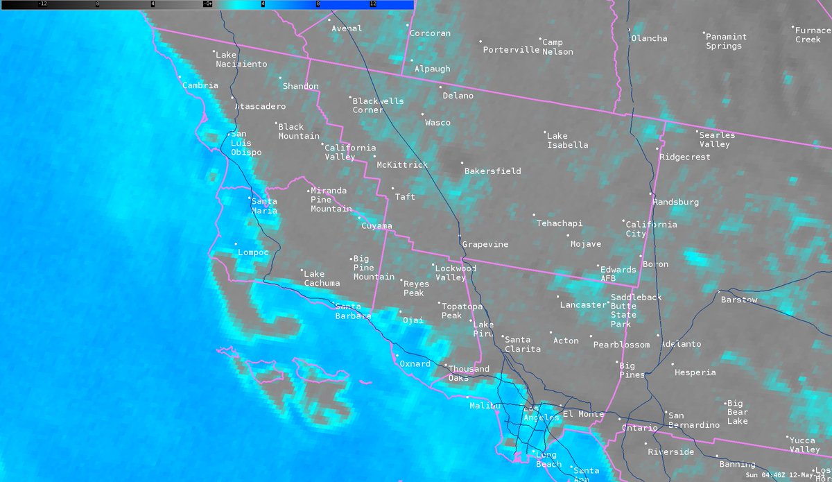
Here's a graphic of current clouds (shown in bright blue), marine layer clouds are expected to continue to creep inland into the valleys and foothills overnight.

Here's a graphic of current clouds (shown in bright blue), marine layer clouds are expected to continue to creep inland into the valleys and foothills overnight. #CAwx #SpaceWeather
account_circle
CAL FIRE(@CAL_FIRE) 's Twitter Profile Photo

Protecting homes from wildfires has evolved since the 60s! As wraps up, let's reflect on the changes. Defensible space now extends up to 100 ft, divided into 3 zones, crucial for slowing or stopping wildfire spread and protecting homes.

account_circle
NWS Los Angeles(@NWSLosAngeles) 's Twitter Profile Photo

Night and morning low clouds will remain persistent across coastal/valley areas through middle of next week, but interior will remain warm and dry, with Antelope Valley approaching 90 degrees for high temperatures.

account_circle
NWS Los Angeles(@NWSLosAngeles) 's Twitter Profile Photo

NWS Los Angeles NWS San Diego National Hurricane Center and our local emergency response partners gathered for our first ever Southern California Tropical Workshop - discussing ways to keep us all safe if a tropical cyclone approaches. Special thank you to our gracious hosts at City of Long Beach
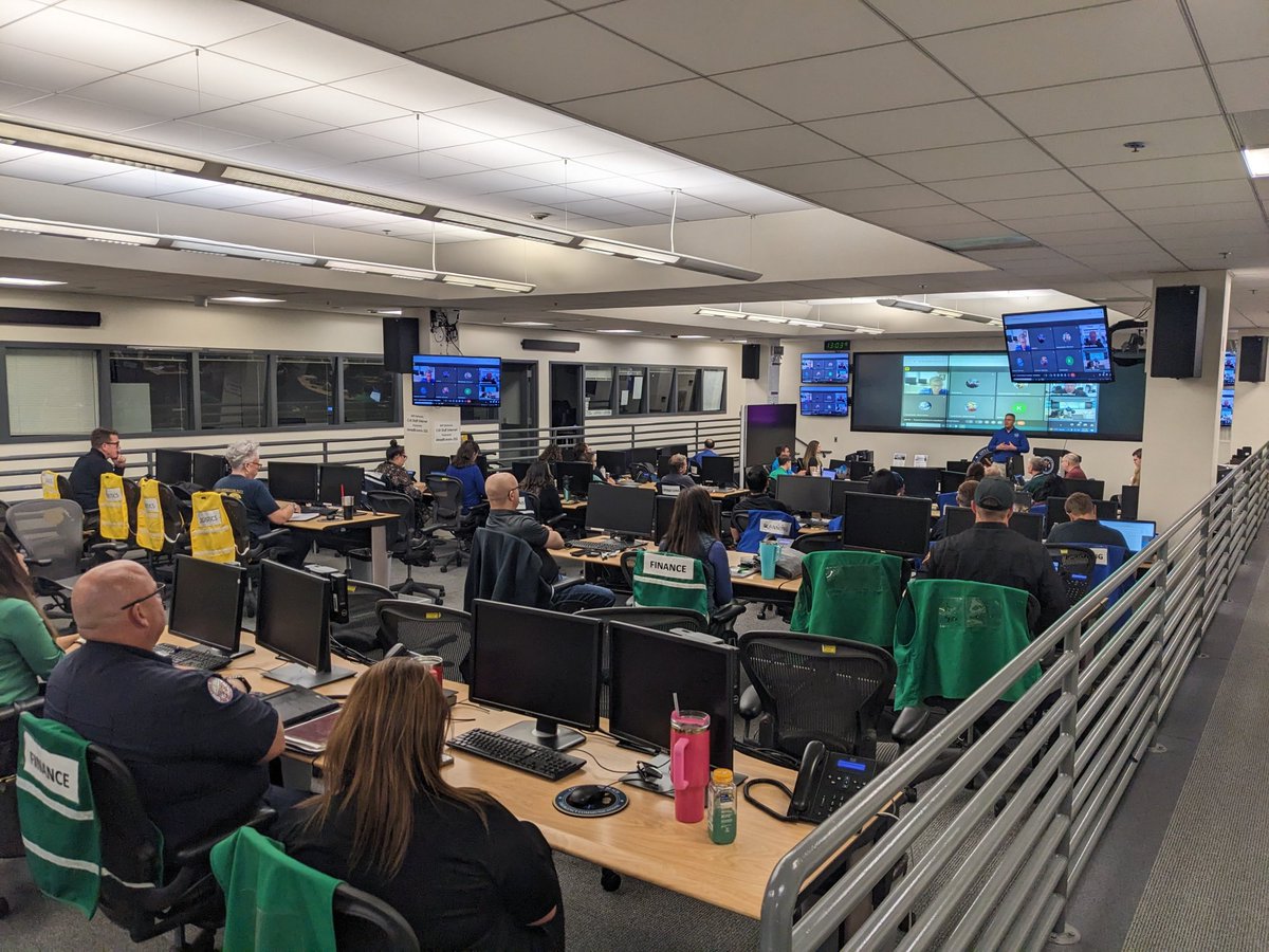
@NWSLosAngeles @NWSSanDiego @NHC_Atlantic and our local emergency response partners gathered for our first ever Southern California Tropical Workshop - discussing ways to keep us all safe if a tropical cyclone approaches. Special thank you to our gracious hosts at @LongBeachCity
account_circle
NWS Los Angeles(@NWSLosAngeles) 's Twitter Profile Photo

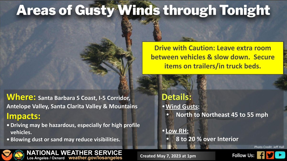
Areas of gusty winds are expected for Santa Barbara south coast, I-5 corridor, Antelope Valley, Santa Clarita Valley and the mtns through tonight. Wind gusts of 45 to 55 mph are expected. Use caution while driving 🙴 leave extra space for high profile vehicles.

Areas of gusty winds are expected for Santa Barbara south coast, I-5 corridor, Antelope Valley, Santa Clarita Valley and the mtns through tonight. Wind gusts of 45 to 55 mph are expected. Use caution while driving 🙴 leave extra space for high profile vehicles. #socal #cawind
account_circle
NWS Los Angeles(@NWSLosAngeles) 's Twitter Profile Photo

A tight pressure gradient brought more gusty winds again Sunday. Here is a summary across , , County, and of all wind gusts more than 35 mph. go.usa.gov/xsdBC

A tight pressure gradient brought more gusty winds again Sunday. Here is a summary across #LACounty, #VenturaCounty, #SantaBarbara County, and #SLOCounty of all wind gusts more than 35 mph. go.usa.gov/xsdBC #CAwx
account_circle
NWS Los Angeles(@NWSLosAngeles) 's Twitter Profile Photo

Beach Hazards Statement issued until 10 pm this evening for west facing beaches of LA/Ventura counties due to elevated surf of 4-7 feet with dangerous rip currents. There is an increased risk of ocean drowning.

account_circle
NWS Los Angeles(@NWSLosAngeles) 's Twitter Profile Photo

You may have noticed rain & wet roads overnight & some of you might have slept through it all (esp. if your area didn't get that much)! Curious on how much rainfall your area got from the weakening front that moved thru? Check it out here: go.usa.gov/xsdZu

account_circle
NWS Los Angeles(@NWSLosAngeles) 's Twitter Profile Photo

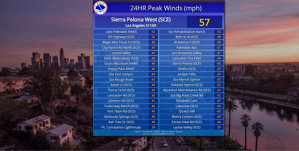
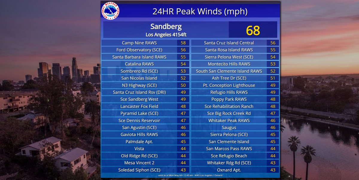
There were some gusty winds across portions of on Saturday. Here are some the strongest wind gusts across our area in the last 24 hours. A larger list can be found here: go.usa.gov/xsdBC

There were some gusty winds across portions of #SoCal on Saturday. Here are some the strongest wind gusts across our area in the last 24 hours. A larger list can be found here: go.usa.gov/xsdBC #CAwx #LAWind
account_circle
NWS Los Angeles(@NWSLosAngeles) 's Twitter Profile Photo

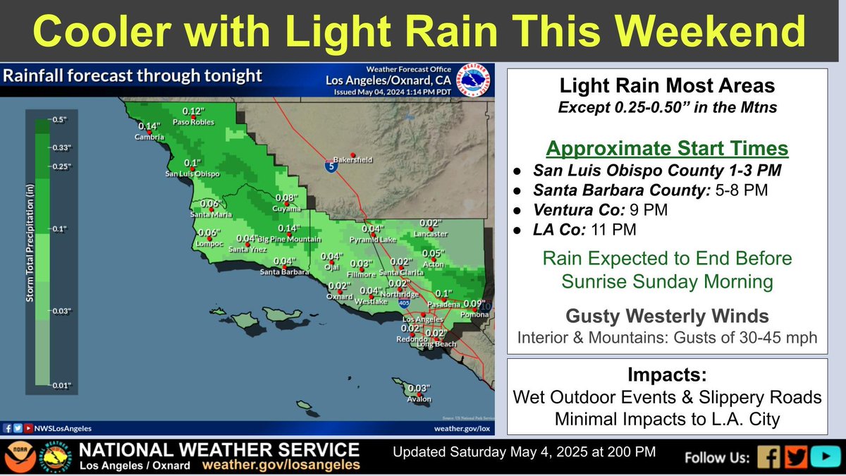
A storm system will bring cooler temps, gusty winds 🙴 light rain to the area this afternoon through early Sunday. Most areas will see light rain or drizzle, but with totals potentially up to 0.50 inch over NW SLO Co. and some mtn locations.

A storm system will bring cooler temps, gusty winds 🙴 light rain to the area this afternoon through early Sunday. Most areas will see light rain or drizzle, but with totals potentially up to 0.50 inch over NW SLO Co. and some mtn locations. #CAwx
account_circle
NWS Los Angeles(@NWSLosAngeles) 's Twitter Profile Photo

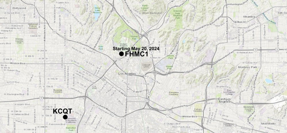
The DT LA weather station is moving to the Frank Hotchkin Memorial Training Center. This new location will be more representative of the weather & climate of DT LA.
Follow the link for more information
weather.gov/lox/DowntownLo…

The DT LA weather station is moving to the Frank Hotchkin Memorial Training Center. This new location will be more representative of the weather & climate of DT LA. Follow the link for more information weather.gov/lox/DowntownLo…
account_circle
NWS Los Angeles(@NWSLosAngeles) 's Twitter Profile Photo

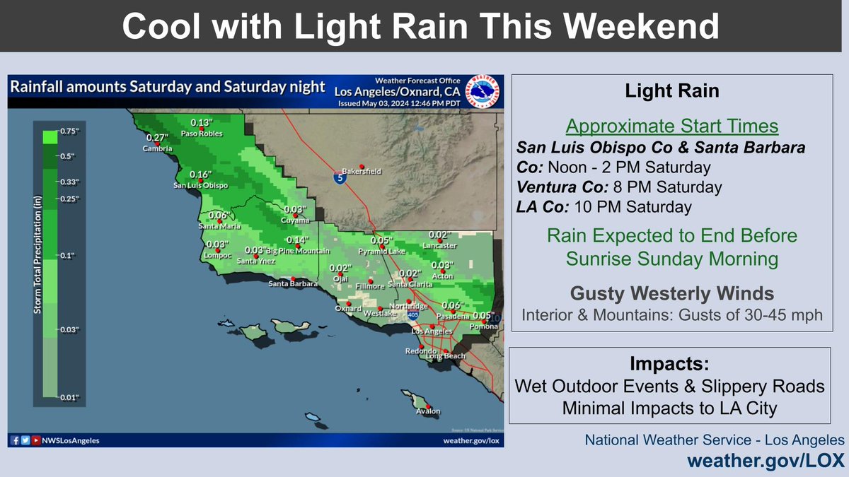
A low pressure system will bring cooler temps, gusty winds, 🙴 light rain to the area this weekend. Rain chances start for the Central Coast Sat PM, and Sat night for Ventura 🙴 LA Counties. Highest rainfall totals will be focused on SLO and higher terrain.

A low pressure system will bring cooler temps, gusty winds, 🙴 light rain to the area this weekend. Rain chances start for the Central Coast Sat PM, and Sat night for Ventura 🙴 LA Counties. Highest rainfall totals will be focused on SLO and higher terrain.
account_circle
NWS Los Angeles(@NWSLosAngeles) 's Twitter Profile Photo

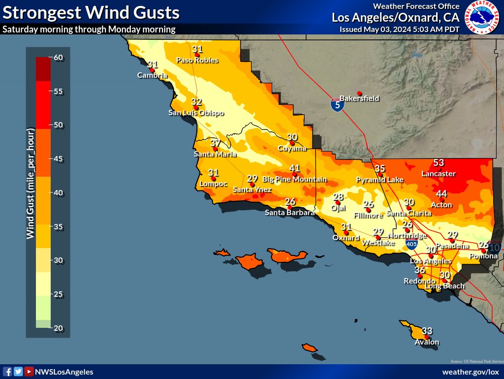
Gusty winds will accompany the cold front this weekend. Here is latest wind gust forecast for Saturday morning through Monday morning.

Gusty winds will accompany the cold front this weekend. Here is latest wind gust forecast for Saturday morning through Monday morning. #CAwx #LAwind
account_circle
NWS Los Angeles(@NWSLosAngeles) 's Twitter Profile Photo

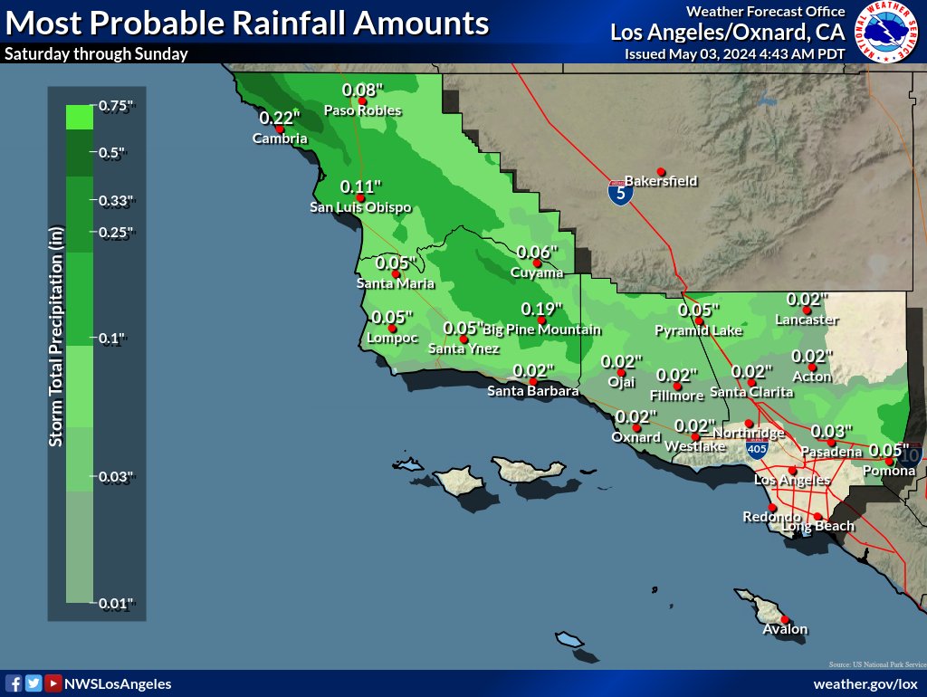
A wet weekend in store? The best chance of rain will for the northern areas along the and into the Interstate 5 Corridor. Rainfall amounts should be 0.25 inch or less, except 0.25-0.50 inch in the foothills.

A wet weekend in store? The best chance of rain will for the northern areas along the #CentralCoast and into the Interstate 5 Corridor. Rainfall amounts should be 0.25 inch or less, except 0.25-0.50 inch in the #SLOCounty foothills. #CAwx #LARain
account_circle