Bernie Rayno(@AccuRayno) 's Twitter Profileg
Bernie Rayno

@AccuRayno

Chief Video Meteorologist for @AccuWeather -Penn State Meteorology Proud (1990)-Eat,Sleep & breathe Green Bay Packers.Views expressed here are my own

ID:288778779

linkhttps://partners.accuweather.com/for-partners/accuweather-network/bernie-rayno/ calendar_today27-04-2011 13:17:02

37,9K Tweets

38,1K Followers

2,4K Following

Bernie Rayno(@AccuRayno) 's Twitter Profile Photo

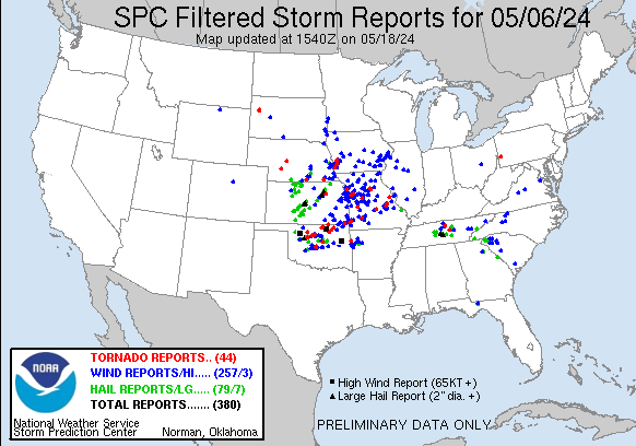
I read a lot of comments pertaining to the 5/06 outbreak being a bust. As usual you must wait until all of the NWS surveys are done. While not the biggest outbreak of the season. The tornado count (filtered) is 44 with a clustering in northern Oklahoma. 380 total reports.

I read a lot of comments pertaining to the 5/06 outbreak being a bust. As usual you must wait until all of the NWS surveys are done. While not the biggest outbreak of the season. The tornado count (filtered) is 44 with a clustering in northern Oklahoma. 380 total reports.
account_circle
Bernie Rayno(@AccuRayno) 's Twitter Profile Photo

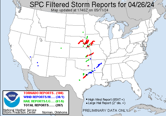
Tuesday looks somewhat similar to set-up on April 26. Close off UL Tue a tad farther to the north and slightly east. I included the SPC reports from April 26 as reference.

Tuesday looks somewhat similar to set-up on April 26. Close off UL Tue a tad farther to the north and slightly east. I included the SPC reports from April 26 as reference.
account_circle
Bernie Rayno(@AccuRayno) 's Twitter Profile Photo

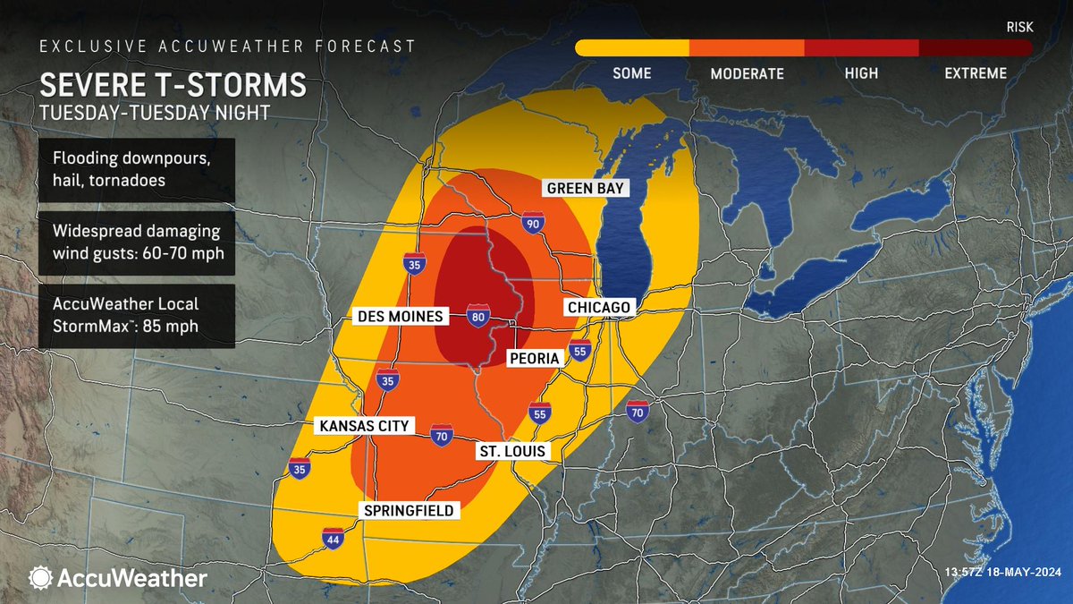
TORNADO OUTBREAK Tue aftn & Tue night.I think there will be DOZENS in area from northern central & southern MO, eastern IA, western IL & southern WI. Strengthening LLJ (left) and UL (middle) with a lifting warm front. We have already issued a high risk (right).

TORNADO OUTBREAK Tue aftn & Tue night.I think there will be DOZENS in area from northern central & southern MO, eastern IA, western IL & southern WI. Strengthening LLJ (left) and UL (middle) with a lifting warm front. We have already issued a high risk (right). #TornadoOutbreak
account_circle
Bernie Rayno(@AccuRayno) 's Twitter Profile Photo

Severe weather outbreak, including tornadoes early next week. Plains Monday, Midwest Tuesday. You can't get a tough this deep coming into California without severe weather 2-3 days later. Chaos to Clarity breaks down the pattern. Watch here: youtube.com/watch?v=kspNoo…

account_circle
Bernie Rayno(@AccuRayno) 's Twitter Profile Photo

If you are a fan and love the NFL draft than you must get the 2024 Green Bay draft guide by the Packer Report . Everything you need is in that report. I purchased on Saturday and I was blown away by the info. I feel as prepared as Brian Gutekunst..well maybe

account_circle
Bernie Rayno(@AccuRayno) 's Twitter Profile Photo

This is my favorite mock draft for my Packers so far. Peter Bukowski Locked on Packers and Andy Herman Pack-A-Day provide excellent information. Mock draft: nflmockdraftdatabase.com/user-mock-draf…
account_circle
Bill Wadell(@BillWadell) 's Twitter Profile Photo

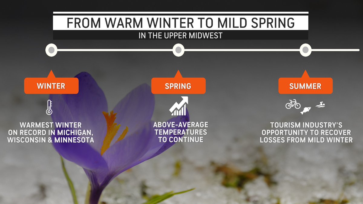
Record-breaking temperatures, lackluster , and little on the Great Lakes hit businesses hard in the Northern Plains and Upper Midwest this past ❄️🌡️

AccuWeather experts estimate the total economic losses in the region at $8 Billion! 📉

Record-breaking #warm temperatures, lackluster #snow, and little #ice on the Great Lakes hit businesses hard in the Northern Plains and Upper Midwest this past #winter❄️🌡️ AccuWeather experts estimate the total economic losses in the region at $8 Billion! 📉
account_circle
Bernie Rayno(@AccuRayno) 's Twitter Profile Photo

I like this mock draft for my packers. I have been listening to Peter Bukowski from Locked on Packers
quite a bit. Seems unlikely Cooper Dejean will be available at #25. It would be great though.
nflmockdraftdatabase.com/user-mock-draf…

account_circle
Bernie Rayno(@AccuRayno) 's Twitter Profile Photo

The biggest snowstorm of the season for the Sierra and Siskiyou mountains is on the way! A blizzard unfolds Fri into Sat with pass closures. This storm may bring Sierra snow amounts to the seasonal average. Additional details below from Ken Clark

account_circle
Bernie Rayno(@AccuRayno) 's Twitter Profile Photo

the BIG BUST FROM ME was WASH D.C. as they NEVER GOT into the heavy precip. BWI went 1/8S+ for a time and got close to the lower end of range (3'). In fact plenty of 3-4' across northern VA, PA and into NJ except for the heavy band from Reading, Allentown and into central NJ.

account_circle