USGS Landsat(@USGSLandsat) 's Twitter Profileg
USGS Landsat

@USGSLandsat

Official USGS account for the Landsat Program - a series of Earth-observing satellites co-managed by @USGS & @NASA. Imaging the Earth since 1972.📡🛰️

ID:75662577

linkhttp://www.usgs.gov/landsat calendar_today19-09-2009 22:53:41

10,2K Tweets

37,2K Followers

223 Following

USGS Landsat(@USGSLandsat) 's Twitter Profile Photo

Part two of the Landsat Next Eyes on Earth episode goes over what needs to be done before the launch to prepare the ground system, data processing, and data calibration. Take a listen here: ow.ly/vGHM50RyKnW

Next

account_circle
USGS Landsat(@USGSLandsat) 's Twitter Profile Photo

The latest Eyes on Earth episodes describe key details about the upcoming Landsat Next mission. Part one goes over how Landsat Next will bring three satellites, 26 spectral bands, and higher spatial and temporal resolutions. Take a listen here: ow.ly/PwG450RyK66

account_circle
USGS Landsat(@USGSLandsat) 's Twitter Profile Photo

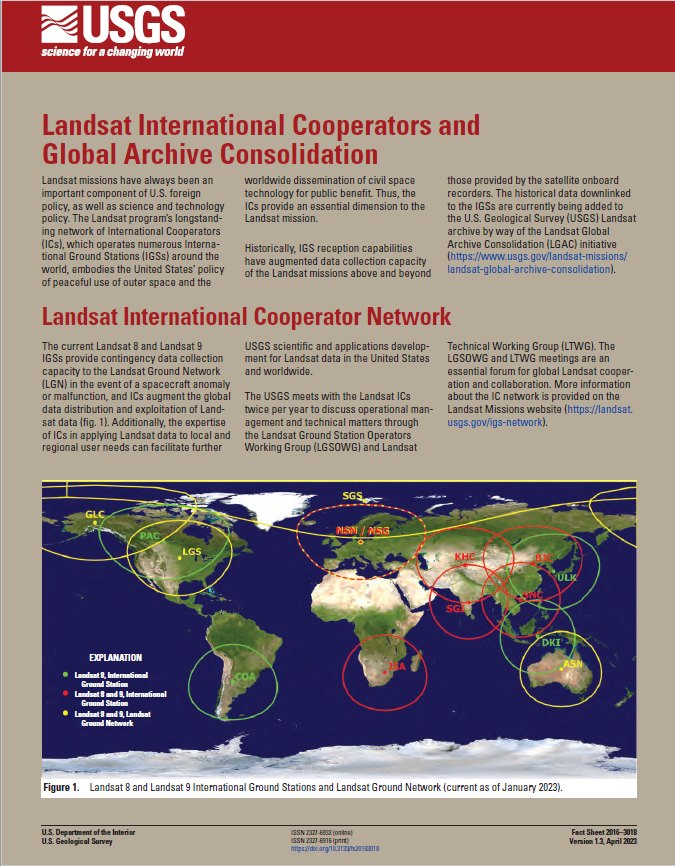
DYK? Landsat has a longstanding network of International Cooperators that operate ground receiving stations worldwide. Learn more about the Landsat IC Network and their contributions to the 50+ year Landsat archive: ow.ly/Z93f50OlGnk.

DYK? Landsat has a longstanding network of International Cooperators that operate ground receiving stations worldwide. Learn more about the Landsat IC Network and their contributions to the 50+ year Landsat archive: ow.ly/Z93f50OlGnk.
account_circle
NASA Landsat(@NASA_Landsat) 's Twitter Profile Photo

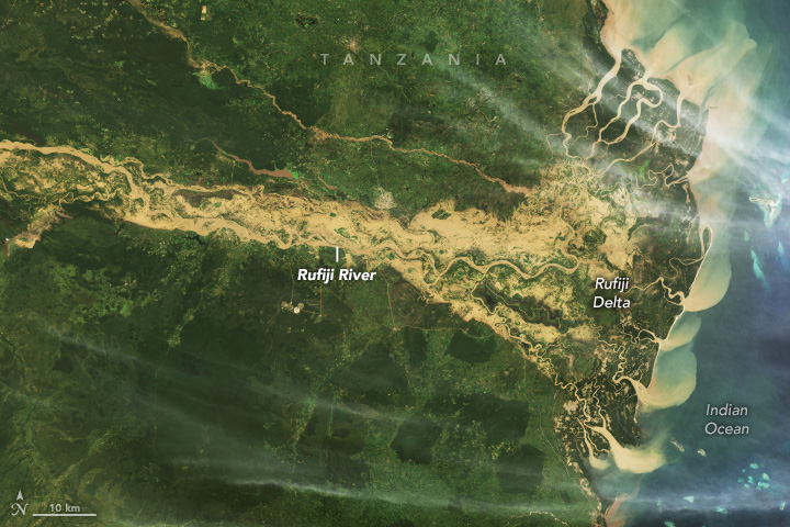
Exacerbated by El Niño, heavy rains in spring 2024 caused severe flooding in Tanzania’s Rufiji district, among other areas in eastern Africa.

A 9 image (right) shows the extent of the flooding along the Rufiji River and its delta.

go.nasa.gov/3UrSkYH

Exacerbated by El Niño, heavy rains in spring 2024 caused severe flooding in Tanzania’s Rufiji district, among other areas in eastern Africa. A #Landsat 9 image (right) shows the extent of the flooding along the Rufiji River and its delta. go.nasa.gov/3UrSkYH
account_circle
USGS Landsat(@USGSLandsat) 's Twitter Profile Photo

May the 4th be with you. Landsat doesn’t travel the galaxy, but it does orbit around Earth to capture land cover change, different ecosystems, and major environmental events.

To learn more about Landsat visit ow.ly/1eMm50Rw9n0

May the 4th be with you. Landsat doesn’t travel the galaxy, but it does orbit around Earth to capture land cover change, different ecosystems, and major environmental events. To learn more about Landsat visit ow.ly/1eMm50Rw9n0 #Landsat #USGS #StarWarsDay
account_circle
USGS Landsat(@USGSLandsat) 's Twitter Profile Photo

2024 was a shortened season for ice anglers in northern Minnesota. images over the past decade show how the ice was affected by the warmer temperatures in this new Image of the Week: ow.ly/xIq050Rv8xg.

account_circle
USGS EROS(@USGS_EROS) 's Twitter Profile Photo

Celebrate a century of discovery, science, and adventure at . Established on May 2, 1924, the monument protects the unique and scenic of the in . Learn about another ancient lava field here: ow.ly/NkPB50Rv6xg.
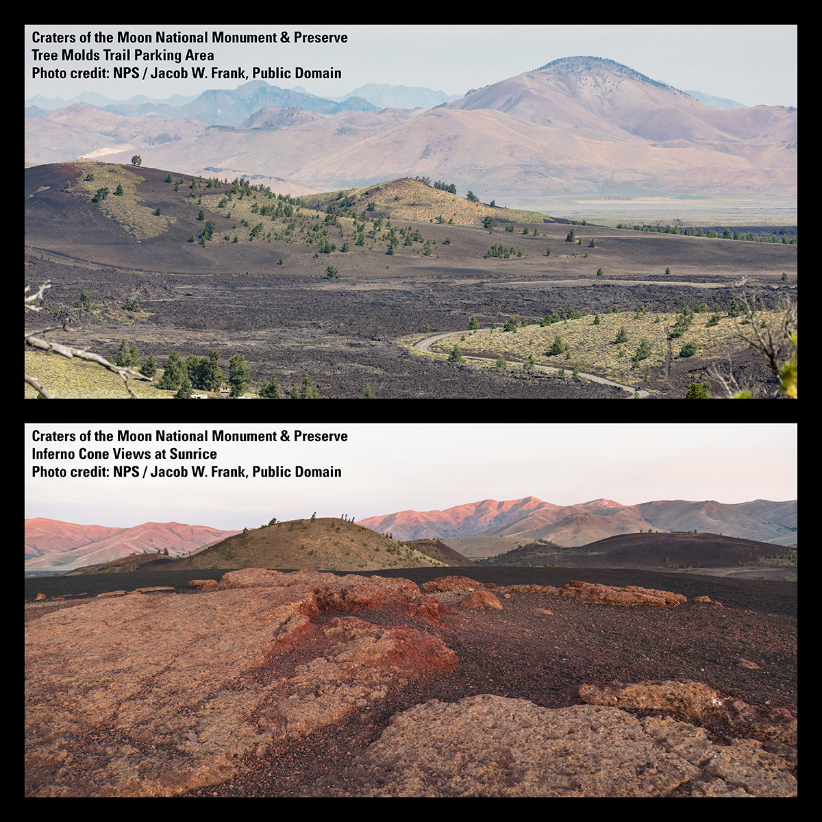
Celebrate a century of discovery, science, and adventure at #CratersoftheMoonNPS. Established on May 2, 1924, the monument protects the unique and scenic #VolcanicLandscapes of the #SnakeRiverPlain in #Idaho. Learn about another ancient lava field here: ow.ly/NkPB50Rv6xg.
account_circle
USGS Climate(@usgs_climate) 's Twitter Profile Photo

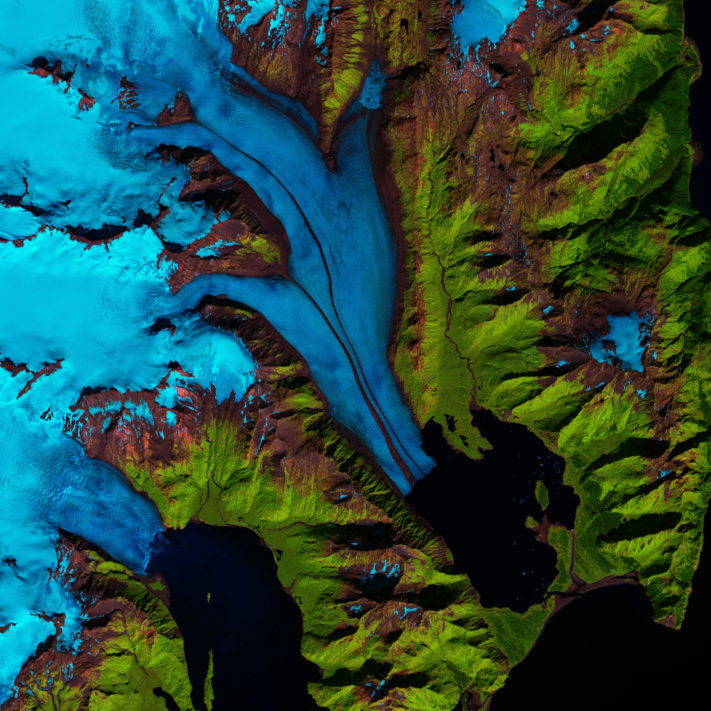
Can we study the effects of climate change from space? With Landsat, we can!

Since 1972, USGS & NASA have been using Landsat satellites to measure things like drought, sea level rise & glacier retreat from space! 🛰️ow.ly/Efsm50RpbrW

@USGS_Landsat

Can we study the effects of climate change from space? With Landsat, we can! Since 1972, USGS & NASA have been using Landsat satellites to measure things like drought, sea level rise & glacier retreat from space! 🛰️ow.ly/Efsm50RpbrW #NationalSpaceDay @USGS_Landsat
account_circle
USGS Landsat(@USGSLandsat) 's Twitter Profile Photo

A new Latest in ! In April, Landsat 7 celebrating its 25th anniversary. The Landsat Quality Assessment ArcGIS toolbox was updated, a new podcast about the upcoming Landsat Next mission was released, and much more! Check out the latest issue here: ow.ly/UUkw50Rubma

A new Latest in #Landsat! In April, Landsat 7 celebrating its 25th anniversary. The Landsat Quality Assessment ArcGIS toolbox was updated, a new podcast about the upcoming Landsat Next mission was released, and much more! Check out the latest issue here: ow.ly/UUkw50Rubma
account_circle
USGS EROS(@USGS_EROS) 's Twitter Profile Photo

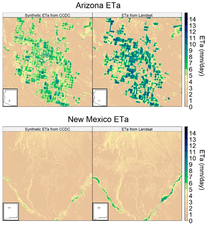
What do you get when you combine two algorithms developed at EROS? Well, a recently published study on land cover monitoring and evapotranspiration may yield new ways to predict drought: ow.ly/U5Ub50Ru9hk

Eyes on Earth podcast with researcher: ow.ly/KgCa50Ru9hj

What do you get when you combine two algorithms developed at EROS? Well, a recently published study on land cover monitoring and evapotranspiration may yield new ways to predict drought: ow.ly/U5Ub50Ru9hk Eyes on Earth podcast with researcher: ow.ly/KgCa50Ru9hj
account_circle
USGS EROS(@USGS_EROS) 's Twitter Profile Photo

Historic storms in August 2023 and February 2024 unleashed nearly 5 inches of rain in . The torrential downpours inundated the region and brought back to . Learn more about changing inland water bodies here: ow.ly/LC2n50RsVw3
account_circle
NASA Landsat(@NASA_Landsat) 's Twitter Profile Photo

Late on April 16, 2024, Ruang, a small volcanic island in Indonesia, unleashed a series of eruptions that, at times, sent plumes of gas and ash into the stratosphere.

This pair of images highlights how the eruption transformed the landscape.

go.nasa.gov/3U4Wsxm

Late on April 16, 2024, Ruang, a small volcanic island in Indonesia, unleashed a series of eruptions that, at times, sent plumes of gas and ash into the stratosphere. This pair of #Landsat images highlights how the eruption transformed the landscape. go.nasa.gov/3U4Wsxm
account_circle
NASA Landsat(@NASA_Landsat) 's Twitter Profile Photo

Southern Romania has become tinged with yellow as rows of rapeseed and canola plants have bloomed. 🌼

8 captured these pops of color near the confluence of the Olt and Danube rivers on April 12, 2024.

go.nasa.gov/4djDOut

Southern Romania has become tinged with yellow as rows of rapeseed and canola plants have bloomed. 🌼 #Landsat 8 captured these pops of color near the confluence of the Olt and Danube rivers on April 12, 2024. go.nasa.gov/4djDOut
account_circle
USGS Landsat(@USGSLandsat) 's Twitter Profile Photo

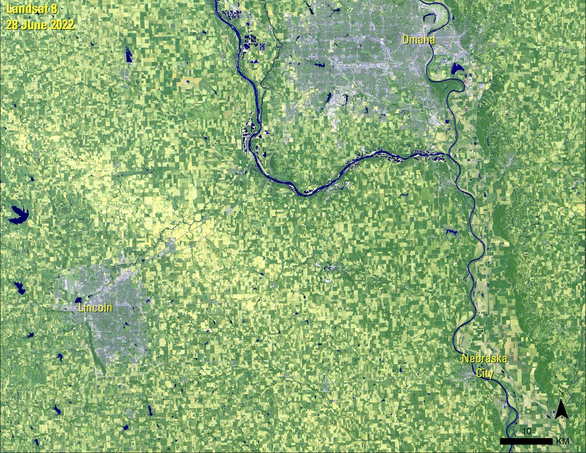
celebrates the importance of trees in our environment. Typically, people plant a tree to commemorate the occasion. The holiday began in Nebraska City, Nebraska, on April 10, 1874. This image shows the area.

#NationalArborDay celebrates the importance of trees in our environment. Typically, people plant a tree to commemorate the occasion. The holiday began in Nebraska City, Nebraska, on April 10, 1874. This #Landsat image shows the area.
account_circle
NASA Landsat(@NASA_Landsat) 's Twitter Profile Photo

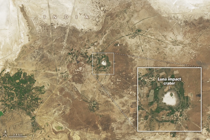
In northwest India, a circular feature has attracted curiosity in recent decades. A geochemical analysis of the area revealed it contains the characteristic signatures of a meteorite impact.

8 captured an image of the Luna impact crater.

go.nasa.gov/3UrWHnJ

In northwest India, a circular feature has attracted curiosity in recent decades. A geochemical analysis of the area revealed it contains the characteristic signatures of a meteorite impact. #Landsat 8 captured an image of the Luna impact crater. go.nasa.gov/3UrWHnJ
account_circle
USGS Landsat(@USGSLandsat) 's Twitter Profile Photo

Landsat data are available to download at no charge  through traditional USGS tools such as EarthExplorer. An Amazon Web Services (AWS) account is required if you prefer to access the data in the cloud, however.

Learn more with this FAQ answer: ow.ly/ij9a50Ro0cT.

Landsat data are available to download at no charge  through traditional USGS tools such as EarthExplorer. An Amazon Web Services (AWS) account is required if you prefer to access the data in the cloud, however. Learn more with this FAQ answer: ow.ly/ij9a50Ro0cT.
account_circle
USGS(@USGS) 's Twitter Profile Photo

Landsat satellites have been capturing images of the Earth's surface for 50+ years.

Not only do they have scientific value, but they're also beautiful to look at (some even resemble famous works of ).

Browse them all ➡️ ow.ly/c1p450RlGTJ

Landsat satellites have been capturing images of the Earth's surface for 50+ years. Not only do they have scientific value, but they're also beautiful to look at (some even resemble famous works of #art). Browse them all ➡️ ow.ly/c1p450RlGTJ #EveryDayIsEarthDay #NASA
account_circle
USGS EROS(@USGS_EROS) 's Twitter Profile Photo

collections bridge the gap between science and art by transforming data into captivating displays of our planet. Explore the stunning landscapes of here: ow.ly/ugfF50QRi4B

account_circle
USGS EROS(@USGS_EROS) 's Twitter Profile Photo

Consider who you’ll nominate for the Pecora 2024 Awards! The deadline is coming soon. Any individual or group who has made significant contributions in satellite or aerial remote sensing of the Earth is eligible. Learn more: ow.ly/mTeF50Rmlcx

Consider who you’ll nominate for the Pecora 2024 Awards! The deadline is coming soon. Any individual or group who has made significant contributions in satellite or aerial remote sensing of the Earth is eligible. Learn more: ow.ly/mTeF50Rmlcx
account_circle
USGS EROS(@USGS_EROS) 's Twitter Profile Photo

Ice anglers had an unusually short season this year in northern Minnesota. This new Image of the Week offers a Landsat look at the past 10 Februarys to see how 2024 treated Mille Lacs Lake much differently. Find a closer view of the lake’s ice roads here: ow.ly/wsr650Rnamy

account_circle