NWS New Orleans(@NWSNewOrleans) 's Twitter Profileg
NWS New Orleans

@NWSNewOrleans

Official Twitter account for the National Weather Service New Orleans. Details: https://t.co/iCJUV7vGsN

ID:594736235

linkhttp://www.weather.gov/neworleans calendar_today30-05-2012 16:53:52

40,8K Tweets

73,5K Followers

302 Following

Follow People
NWS New Orleans(@NWSNewOrleans) 's Twitter Profile Photo

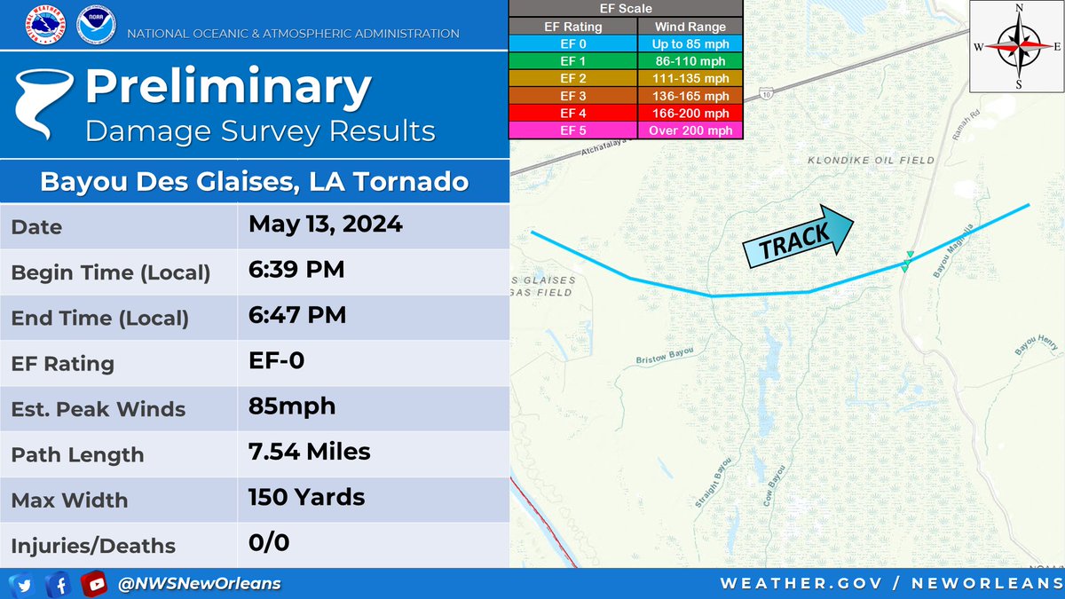
🌪️We have confirmed 3 more tornadoes across the area from the May 13th event after analyzing high-res satellite and storm survey data. The strongest one is an EF-1 that impacted Livingston Parish.

🛰️Further updates are possible as we comb through more satellite data.

🌪️We have confirmed 3 more tornadoes across the area from the May 13th event after analyzing high-res satellite and storm survey data. The strongest one is an EF-1 that impacted Livingston Parish. 🛰️Further updates are possible as we comb through more satellite data.
account_circle
NWS New Orleans(@NWSNewOrleans) 's Twitter Profile Photo

Remember, it only takes ONE storm to cause a year to be a bad year. Take some time now to make sure you are prepared and have a plan. Before the season starts, check your supplies and refresh as needed. Keep an eye on the tropical forecasts during hurricane season.

account_circle
NWS New Orleans(@NWSNewOrleans) 's Twitter Profile Photo

[Reposted due to original quote getting deleted]
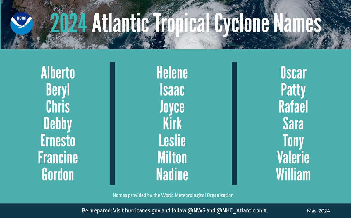
The 2024 Atlantic Hurricane Season Outlook (June 1 - November 2024) just got issued.
NOAA is predicting and above-normal year with:
🔹17-15 Named Storms
🔹8-13 Hurricanes
🔹4-7 Major Hurricanes

[Reposted due to original quote getting deleted] The 2024 Atlantic Hurricane Season Outlook (June 1 - November 2024) just got issued. NOAA is predicting and above-normal year with: 🔹17-15 Named Storms 🔹8-13 Hurricanes 🔹4-7 Major Hurricanes
account_circle
NWS New Orleans(@NWSNewOrleans) 's Twitter Profile Photo

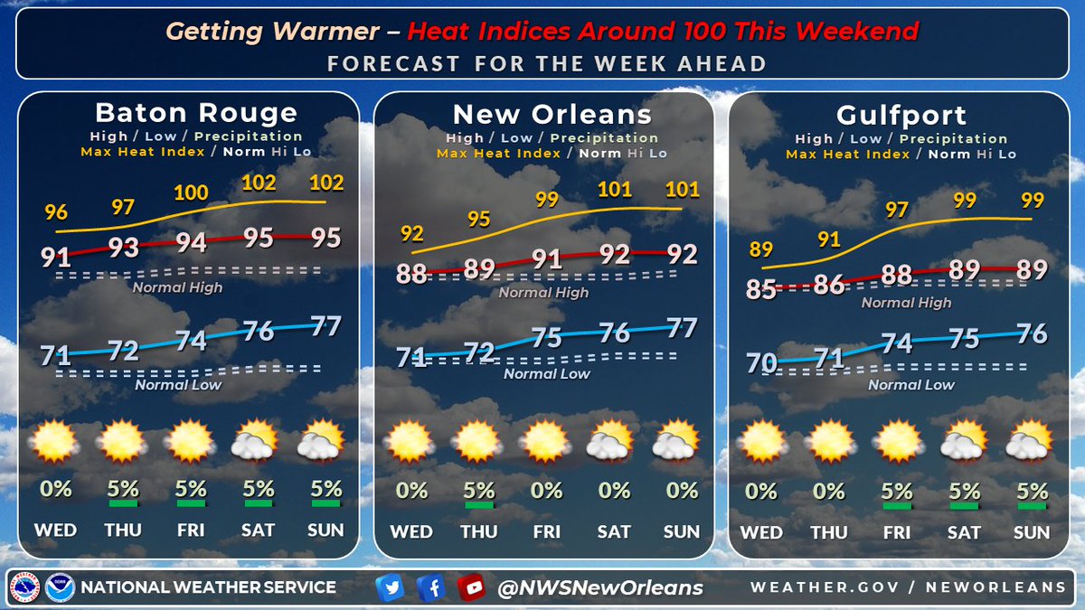
🌡️ The heat continues to build going into your Memorial Day Weekend, with afternoon heat indices surpassing 100 to even 105 in a few places thru Monday. Can't rule out an isolated shower early this morning, and again Monday, but primarily dry. Stay cool & be safe!

🌡️ The heat continues to build going into your Memorial Day Weekend, with afternoon heat indices surpassing 100 to even 105 in a few places thru Monday. Can't rule out an isolated shower early this morning, and again Monday, but primarily dry. Stay cool & be safe! #lawx #mswx
account_circle
NWS New Orleans(@NWSNewOrleans) 's Twitter Profile Photo

Just a reminder everyone we are approaching the start of hurricane season, beginning June 1st. Tomorrow NOAA will release their Atlantic Hurricane Season Outlook, so be on the lookout for that.

account_circle
NWS New Orleans(@NWSNewOrleans) 's Twitter Profile Photo

🔥Heat continues to be the main story, especially as we get into the weekend. Hazardous heat with heat indices nearing 105 will be possible throughout the weekend and into Memorial Day!

account_circle
NWS New Orleans(@NWSNewOrleans) 's Twitter Profile Photo

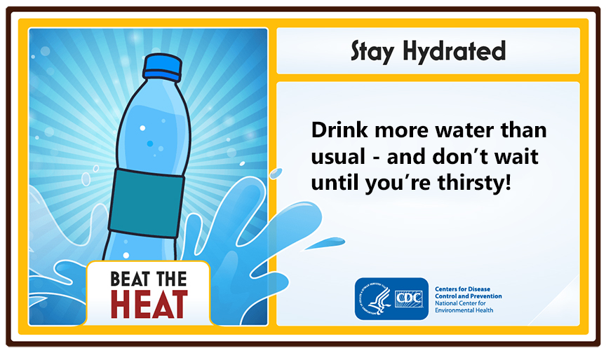
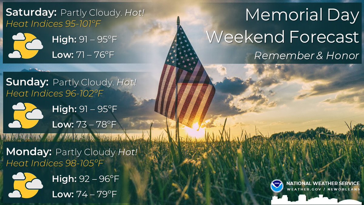
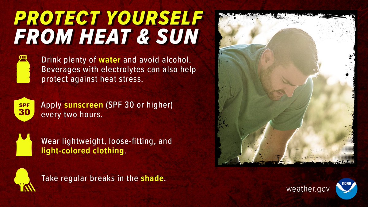
No major changes in your Memorial Day weekend forecast as temperatures are looking HOT! Remember if you plan to spend time outdoors for an extended period, wear sunscreen, hydrate, and take frequent breaks in the shade or indoors.

No major changes in your Memorial Day weekend forecast as temperatures are looking HOT! Remember if you plan to spend time outdoors for an extended period, wear sunscreen, hydrate, and take frequent breaks in the shade or indoors. #lawx #mswx
account_circle
NWS New Orleans(@NWSNewOrleans) 's Twitter Profile Photo

🥵 Forecast continues to advertise warming temps with our warmest days of the year so far expected this Memorial Weekend. If you're at any outdoor memorial services, ceremonies, or events prepare for highs in the 90s & heat indices in the upper 90s to lower 100s.

🥵 Forecast continues to advertise warming temps with our warmest days of the year so far expected this Memorial Weekend. If you're at any outdoor memorial services, ceremonies, or events prepare for highs in the 90s & heat indices in the upper 90s to lower 100s. #MSwx #LAwx
account_circle
NWS New Orleans(@NWSNewOrleans) 's Twitter Profile Photo

🌡️If you plan on being outside this weekend to commemorate Memorial Day, make sure you practice these heat safety tips.

🔥Heat indices will be in the 100-105 range this weekend and Memorial Day.

🌡️If you plan on being outside this weekend to commemorate Memorial Day, make sure you practice these heat safety tips. 🔥Heat indices will be in the 100-105 range this weekend and Memorial Day.
account_circle
NWS Mobile(@NWSMobile) 's Twitter Profile Photo

🚤Tomorrow kicks off 2024 National Safe Boating Week (May 18-24).
🦺 The National Weather Service partnered with the @boatingcampaign to help promote safe boating practices.
⛵Find out what you should do before you go & while you are out!
🖱️weather.gov/safety/safeboa…

🚤Tomorrow kicks off 2024 National Safe Boating Week (May 18-24). 🦺 The @NWS partnered with the @boatingcampaign to help promote safe boating practices. ⛵Find out what you should do before you go & while you are out! #SafeBoating 🖱️weather.gov/safety/safeboa…
account_circle
NWS New Orleans(@NWSNewOrleans) 's Twitter Profile Photo

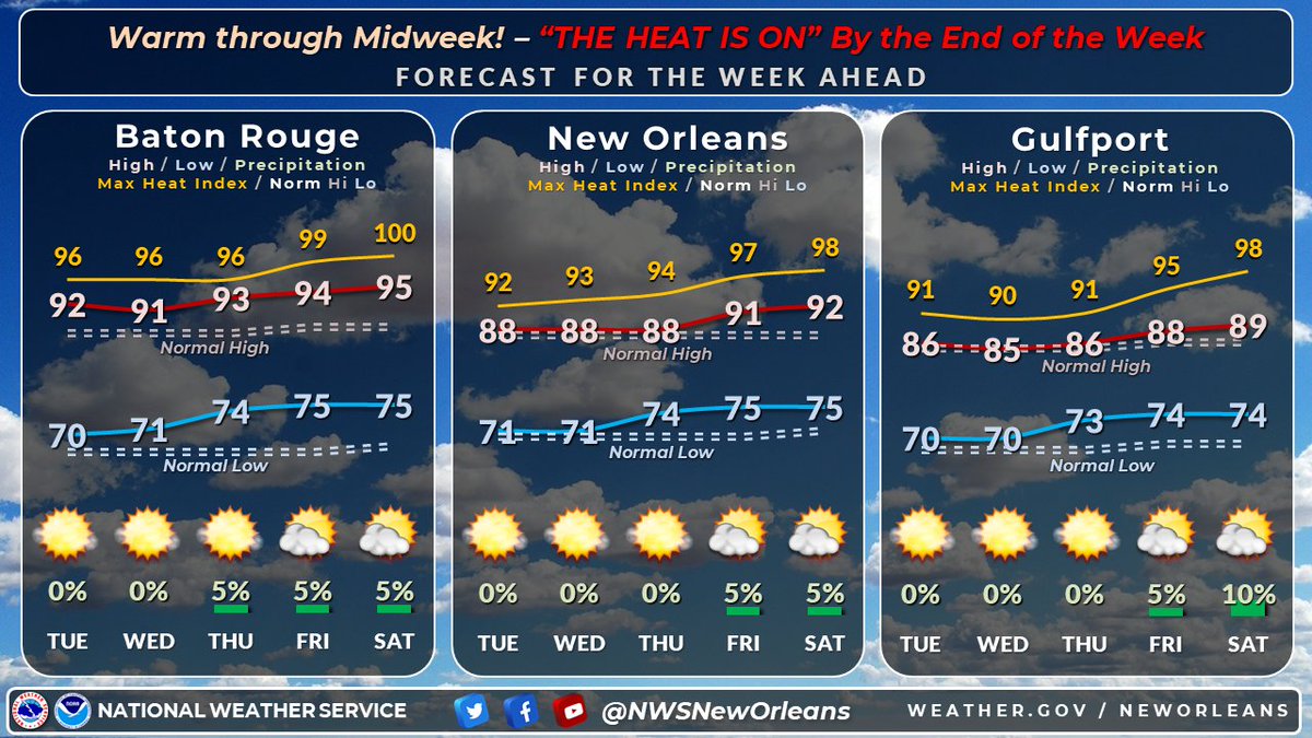
🥵'The heat is on, yeah it's on the street'🎶...by the end of the end of the week. Warm temperatures through midweek but as we head into the end of the week and weekend we start to heat up with the heat indices approaching 100.

🥵'The heat is on, yeah it's on the street'🎶...by the end of the end of the week. Warm temperatures through midweek but as we head into the end of the week and weekend we start to heat up with the heat indices approaching 100. #LAwx #MSwx
account_circle
NWS New Orleans(@NWSNewOrleans) 's Twitter Profile Photo

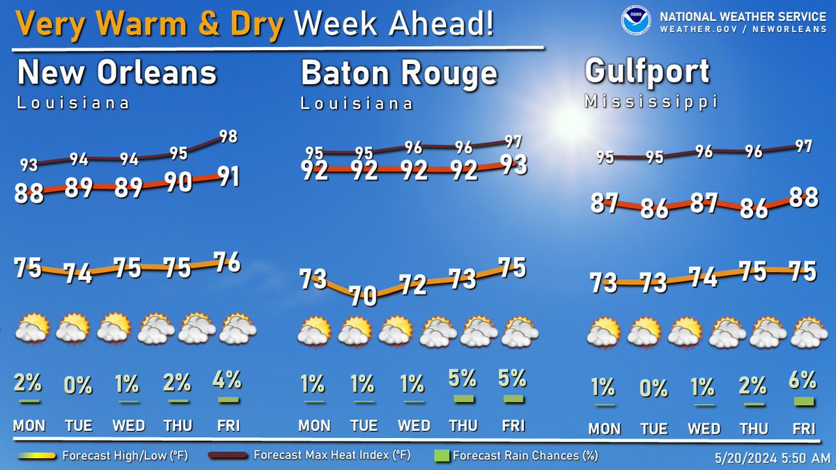
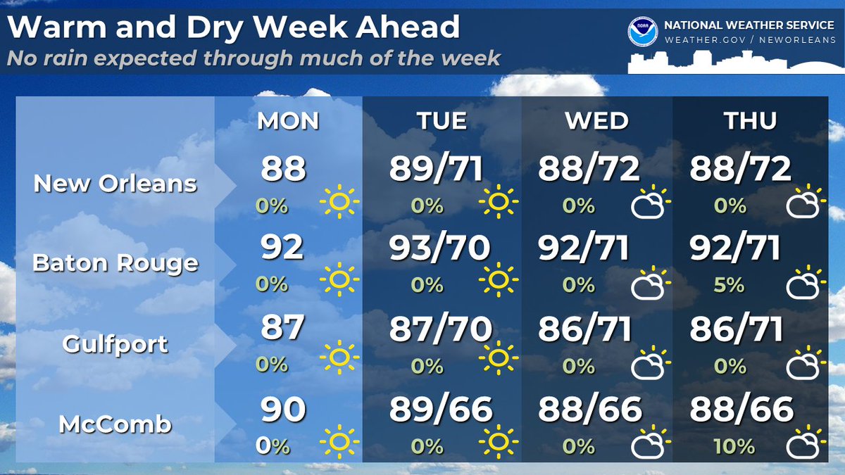
😒 It's Monday already?! Welp, not much going on this week with dry conditions and very warm (if not hot) afternoon highs. Heat indices build later in the week, so remember to take breaks if planning to be outdoors for extended periods.

😒 It's Monday already?! Welp, not much going on this week with dry conditions and very warm (if not hot) afternoon highs. Heat indices build later in the week, so remember to take breaks if planning to be outdoors for extended periods. #lawx #mswx
account_circle
NWS New Orleans(@NWSNewOrleans) 's Twitter Profile Photo

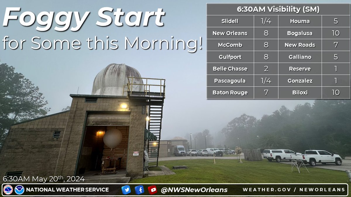
🌫️ There's some patchy fog out and about in some areas early this morning! Use caution if traveling during your morning commute. Take it slow, give yourself some space and plan accordingly. Fog will dissipate shortly by mid-morning.

🌫️ There's some patchy fog out and about in some areas early this morning! Use caution if traveling during your morning commute. Take it slow, give yourself some space and plan accordingly. Fog will dissipate shortly by mid-morning. #lawx #mswx
account_circle
NWS New Orleans(@NWSNewOrleans) 's Twitter Profile Photo

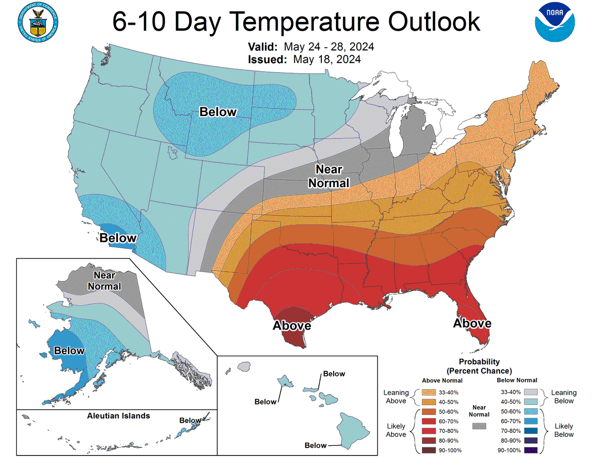
🌡️According to CPC, above average temperatures seem likely to stick around as we get into the end of May. Summer is coming up quick!

🌡️According to CPC, above average temperatures seem likely to stick around as we get into the end of May. Summer is coming up quick!
account_circle
NWS New Orleans(@NWSNewOrleans) 's Twitter Profile Photo

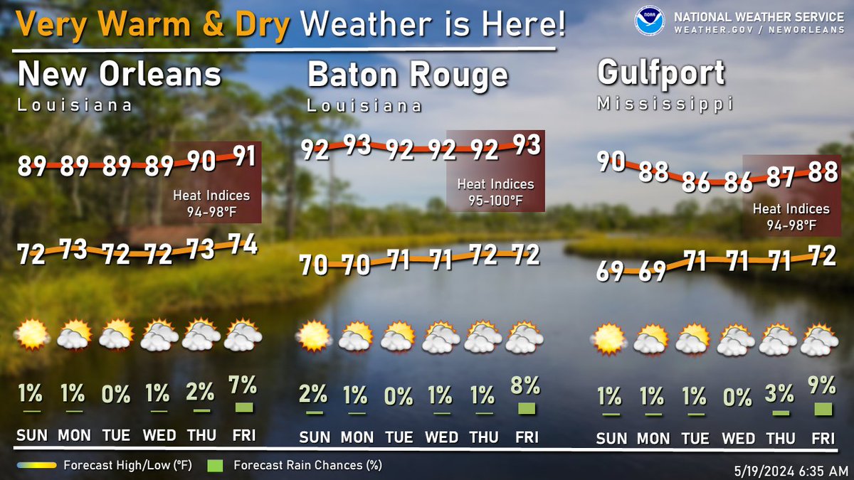
Are you over this rainy/stormy weather pattern? Well...here ya go.

No rain thru next week. Warm (hot) and dry! Have a great Sunday and wonderful week ahead!

Are you over this rainy/stormy weather pattern? Well...here ya go. No rain thru next week. Warm (hot) and dry! Have a great Sunday and wonderful week ahead! #lawx #mswx
account_circle